
Building control in Bradford
Deposited building plans, their origins and uses with particular reference to Little Germany
Geoffrey Manuel
(First published in 1991 in volume 5, pp. 57-68, of the third series of The Bradford Antiquary, the journal of the Bradford Historical and Antiquarian Society.)
Three years after the incorporation of the Borough of Bradford in 1847 the Council obtained a local Act of Parliament to enable it to regulate better a wide range of activitics within the Borough. The Bradford Improvement Act,1 taking effect on 25 September 1850, included many of the clauses from the epic Public Health Act of 18482 as well as parts of the Towns Improvement Clauses Act3 and the Town Police Clauses Act4 (both 1847). It extended the more limited powers of an earlier local Act of 18035 (which it repealed) and also replaced the provisions of a general Act 'to provide for the Regulation of Municipal Corporations in England & Wales'6 (1835) which the Council had adopted shortly after its incorporation.
The powers of these various Acts of Parliament were ceded to bring some order to the chaotic and uncontrolled growth of Bradford which, in common with other nineteenth-century industrial towns, was struggling with the social and health problems of rapid urbanisation. The provisions of the 1803 Act had attempted some basic 'cleansing' of the streets, had required property owners to 'well and sufficiently pave' the footpaths opposite their buildings and had tried to have 'annoyances' and 'nuisances' removed from the streets including wandering cattle and swine. As far as buildings were concerned the only provisions were for the construction of elementary sewers and the prevention of projections from buildings and openings in pavements which might cause danger to passers-by. Armed with 'one wheelbarrow, two shovels, two coal rakes, two besoms and one water pan' two 'proper persons' were set to work as scavengers. But, after various schemes were tried, little was achieved and the streets became so filthy that a writer of the time said they would 'disgrace a Hottentot settlement'.7
By 1850, with the passing of the Improvement Act, more determined efforts to tackle some of the major urban problems, particularly those identified as health hazards, were being made. From the 1848 Public Health Act (as embodied in the Improvement Act) came the requirement that 'no new house was to be built without proper drains' ('proper' being undefined!), that 'sufficient watercloset or privy accommodation and ashpits, furnished with proper doors and coverings' must be provided and - important in the context of this article - 'written notice of building and rebuilding' must be offered to the Council for approval before building could begin. Approval was also required before any new street was laid out and plans had to be submitted to show the intended level and width. Any proposed building projecting beyond the general street line would be 'disapproved' as would any with the familiar 'obstructions' and 'projections' from the earlier Acts. As far as public buildings were concerned, a notice of intent was required with a plan and description showing the means of supplying fresh air - that rarest of commodities in 1850! Streets were to be named and houses to be numbered although it was many years before numbering became a universal practice.
Thus, 1850 marks the real beginning of a form of planning control at the local level and the 'notices' required by the Council took the form of a 'building plan' which was deposited with them - hence 'Deposited Building Plans'. They gave, in a manuscript note on the plans themselves. an indication of the type of property and a reference, often vague, to its location, name of owner and architect and, of course, details of the drains. After perusal by the Council they were countersigned as 'approved' or 'disapproved' and, if rejected, the reason was usually written on the plans by the Chairman of the delegated Committee. The plans are serially numbered in a simple chronological sequence. Plan No. 1, submitted by the well known local architects Andrews & Delauney is for seventeen houses in Lumb Lane for the Crown Building Society and is dated 15 October 1850 (it was approved with crisp attention - in this case by the full Council - three days later). The last plan in the series submitted to Bradford Borough Council is No. 100299 for a garage in Wibsey and is dated 30 January 1974. Planning control was taken over by the City of Bradford Metropolitan Council and plans continue to be submitted to the new authority.
Regrettably, many of the plans were missing by the time they were transferred by the Council's Planning Division from the attics of City Hall to the care of the Archive Service in the years following 1974. However. the majority do survive: they have recently been copied on to microfilm and these copies are now available in the searchroom of the Bradford Archives. A bound Index (also now on microfilm) was maintained which simply gives the street, building type, name of the applicant and the date of approval. Unfortunately the name of the architect, although given on the plans themselves, is not shown in the index and it is not possible, therefore, to ascribe any of the missing plans to a specific architectural firm. By the same token it is not possible to obtain an overview of the work of individual architects by skimming the index.8 It has already been noted that the Bradford Improvement Act took effect from 25 September 1850 and the Council lost no time in setting up its internal machinery to handle the new flow of business. A Street & Drainage Committee was established and among its special powers was the authority 'to approve or disapprove of the plans for the erection or rebuilding of houses'.9 At its first meeting on 2 October 1850 it promptly appointed a sub-committee 'to inspect and report on notices to build': this body settled down to its task with vigour. approving a rebuild of a house in Great Horton Lane for a Mr. Edward Theophilus Tetley, an ale and porter store in Manchester Road for Mr. Pullan, brewer, and a couple of shops in Stott Hill for Mr. William Reynolds. Building Plan No. 4, for three houses in Manningham carries the stern comment (the first of many such over the years) from George Rogers, Chairman of the Committee, that 'each house must be provided with a privy in suitable situations'.
After a mere six months the Street & Drainage Committee decided to try to relinquish its special powers: they recommended that a new Building & Improvement Committee should be established to undertake, inter alia, the job of planning approvals.10 This new committee was accordingly created by the Council on 15th April 185111 and, at its opening meeting on the following day, tackled its first batch of approvals.12 The committee was certainly kept busy. For instance, in 1852/3 there were plans put forward for 71 new streets and 1772 buildings, including 48 warehouses and mills:13 1854 produced 68 new streets and 34 warehouses/mills out of a total of 1669 buildings.14 Indeed the growth of the city and its industrial core can be measured by the building plan activity through the years. The Building and Improvement Committee was also responsible for the supervision of Mr. Edward Walker Shaw, recently appointed Borough Surveyor from a field of 72 applicants with an impossibly exacting job specification and a salary of £150 a year.15
Returning now to the Building Plans themselves, some mention must be made of the difficulties and limitations which the earlier ones present to a researcher. Many of them were drawn on a tracing paper which has become brittle with age and they now have the texture of a crisp poppadam - vital parts of the drawings simply crumble away when they are opened: those drawn on linen have fared better. Hence some of the microfilm copies of early plans are incomplete but, at least, the need to handle the originals again should not often arise. Even from well-established firms the draughtsmanship and legibility is often poor and one has the impression that their preparation was not infrequently delegated to the most junior clerk: it is, perhaps, not surprising that the minimum amount of professional effort was expended since there was neither payment for them nor the need to impress a client. Furthermore, the customary reactions to a new flood of rules and regulations from the local bureaucracy were presumably little different than they tend to be today.
It has to be understood that the Plans are not and were never intended to be full architectural drawings and the limited purpose for which they were required must be appreciated. There is usually a plan of each floor of the building (at a scale of 8' = 1"), the ground floor plan normally giving the name of the adjoining street(s) and owners of neighbouring property: there are one or more sectional drawings which are useful in revealing the height of the building and the number of floors. Detail is limited and, unfortunately, elevations were not required and so are not normally provided. This lack not only reduces the intrinsic interest of the drawings but adds to the difficulty of verifying a plan against an existing building. Since the local authority was not concerned at this time with aesthetic considerations or the impact of a new building on the streetscape the Building Plans rarely show what a building actually looked like. With the next cholera epidemic round the corner the local authority was clearly more concerned with basic matters of health and safety rather than the appropriate application of the Gothic or Italianate style!
Despite the provisions of various Acts, street numbering on the earlier plans is almost unknown, adding a further limitation to positive identification. Certainly none of the surviving plans for the warehouses in the Little Germany area (to be described later) carry street numbers and Bradford must still have been enough of a village in the 1850s and 1860s for such descriptions as 'a new warehouse in Burnett Street next to Mr. Dunlop' to be sufficient identification. The 'seventeen houses in Lumb Lane' in Plan No. 1 already mentioned may be anywhere in a fairly long street but, on reflection, does the exact location really matter to the Building & Improvement Committee as long as the drains go somewhere? Street Directories are of little help (they will merely confirm that Mr. Dunlop lived in Burnett Street) and it is not until the excellent Post Office Directory of 1879/80 that the ground becomes firm. Very few of the warehouses in Little Germany are physically marked with their street numbers even to this day!
A further problem may arise in making a positive identification from the plans. They often show a proposed building at the corner of a pair of intersecting streets: there are, of course, four such possible corners and, without any apparent conventions about orientation of plans - or even a helpful arrow pointing north one is left to guess which one is actually intended!
However, given the limitations described, the Building Plans are of very great interest and help to a researcher. For those with the time and patience to follow them thoroughly they give a unique picture of the development of the town and the increasing requirements of the local authority over the years. Since the name of the architect is usually given on the plans they are an important primary source for the corroboration of an architect's work. But in this context it is a pity that so many are missing and, inevitably, many of those by the most prominent local firms and those of the most important public buildings have vanished.
These general observations about the Building Plans in the Bradford Archives arise from a research project to identify the surviving plans for the warehouses in the Little Germany area. The rest of this article is devoted to the findings of this exercise. Its purpose is not to describe the area and its buildings in detail since they have already been thoroughly examined:16 in addition most of the buildings are Grade II listed and the Department of the Environment formal descriptions are also available.17 However, for those readers who may be unfamiliar with this district of Bradford, a brief introduction may be useful.
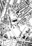
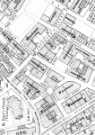
Specifically, and for the purposes of this article, Little Germany is taken to be that part of Bradford lying on the sloping ground south east of the Cathedral and bounded, to form an irregular pentagon, by Church Bank/Barkerend, Upper Park Gate, East Parade, Leeds Road & Well Street. It was church land until sold for development in the 1850s and the open aspect of this part of Bradford is evident in T. Dixon's map of Bradford surveyed in 1844-46.
The area was largely developed in the twenty years from about 1853 (Field Street & Currer Street, for instance being laid out by approval of Building Plan No. 969 on 2 February of that year). Although there were a few domestic properties built. most of the new buildings were medium to large-sized warehouses designed for the storage, display and sale of finished worsted goods - mainly for export trade. Many of these 'stuff' warehouses were commissioned and used by German merchants who had settled in Bradford - hence 'Little Germany'. The buildings were usually designed by the best local architects of the day and most of them were in the fashion of Italian palazzi following the stylistic trend set by Andrews and Delauney in their 1852/3 design for the Milligan & Forbes Home stuff warehouse in Hall Ings (now the offices of the Bradford Telegraph & Argus). Only two surviving warehouses depart from this generally accepted style George Corson's splendid Scottish Baronial for William Dunlop at 46 Peckover Street and the wildly extravagant Gothic of 51/53 Well Street, possibly by Eli Milnes, which cheerfully flouts the generally accepted maxim that decoration decreases with height! If this is, indeed, Eli Milnes (and, unhappily, there is no Building Plan to be found) then it is somewhat out of character to the restrained approach of most of his other designs. These two buildings apart, the Italianate gives a strong coherence and unity to the area, almost as if it had been centrally guided - as already noted, however, style was of no concern to the worthy gentlemen of the Building & Improvement Committee.
Most of the warehouses survive and with the resurgence of interest and growing appreciation of these handsome buildings more of them are being found new uses in a much changed world. Some have. of course, been lost and a number of Building Plans still exist for those which have been demolished. For instance, the block between Church Bank and Currer Street, behind 39/45 Well Street (now a car park), had a chequered history. Lockwood & Mawson produced a plan for one warehouse for Mr. T. Mills and this was approved on 12 November 1858 (Plan No. 2694). Just over four years later the same firm (plus an additional 'Mawson') produced, for the same client, plans for a block of five warehouses on the site (Plan No. 3430, approved 20 January 1863). It is not clear whether or not these replaced the original warehouse or added to it. Finally there seems to have been a complete rebuild (same client, same architects) approved, as Plan No. 9990, on 19 December 1877. All that now remains is a grimy bricked-in doorway of some distinction hanging forlornly to the back of Pennine House. A 'lost' building on the corner of Burnett Street and Peckover Street (now Festival Square) may be the one referenced in Plan No. 2045 and received in the Borough Surveyor's office by date stamp on 30 September 1855. It seems to fit the one shown on Goad's Insurance Map of Bradford for 1886 (a most valuable additional source of reference).18

The searches have revealed 18 Building Plans for existing buildings in the area together with a further 4 which specify additions or alterations. Three plans which are missing can fairly certainly be associated with existing counterparts from the limited information in the Building Plan Index. This shows a disappointingly low survival there is practically nothing for that part of Well Street lying within the Little Germany boundaries and all is missing for Chapel Street where it appears that Andrews, partnered first by Delauney and then by Pepper, made a significant architectural contribution.
In a few cases the plans seem to indicate that architects other than those normally attributed were, in fact, responsible for the designs. For instance, 47 Well Street appears to be an early (1854) Andrews & Delauney design; 4 Currer Street (the Downs Coulter building) corresponds in all major respects to an Andrews & Delauney plan of 1859 with its extension by Andrews, Son & Pepper in 1866 (the join is clearly visible on both the Vicar Lane & Field Street elevations). Both these warehouses are generally credited to Lockwood & Mawson. 13 Currer Street, whose architect appears to be generally unknown, proves to be a late work (for this area) by Hope & Jardine (1875); 4/6 Burnett Street and, on the opposite side, 5 Burnett Street correspond to plans submitted by Eli Milnes.
Two minor delights surfaced during the search - a neo-Gothic Cabmans Shelter in Well Street (Plan No. 11025, approved 10 August 1881) and a Circus in Peckover Street (Plan No 6150, approved 6 April 1870). Two further points should be made. Firstly, for anyone who needs to examine any of the earlier plans, it should be noted that Church Street (as given in some of the plans) was re-named Peckover Street - this is likely to have occurred some time between 1852 and 1856. Secondly, it is sad to note that the Grade II Listed Building at 14 Peckover Street has now vanished and its replacement is hardly likely to win any accolade!
A detailed list of the result of the searches is given below. All buildings mentioned are also described in the Department of the Environment schedule of listed buildings.
| 1 Burnett Street | corner site with Cater Street, now Gallon House (British International Hotel). Plan No. 4465: new warehouse for Wm. Schaub by Milnes & France, July 1866. Plan 'disapproved' 15 Aug & 19 Sept 1866 but no record on plan of final date of approval. |
| 2 Burnett Street | corner site with Cater Street and known as Cater Buildings (described in error as 1 Burnett Street in the Listed Building Schedule). Plan No. 3315: warehouse in Burnett Street & Cator (sic) Street for E.E. Barthelmes by Eli Milnes, approved 28 May 1862. |
| 4/6 Burnett Street | includes 8 Peckover Street and now called Atomik House. Plan No. 2502: proposed warehouse in Peckover Street for E. Milnes, designed Eli Milnes and approved 2 Sept 1857. |
| 5 Burnett Street | corner with Peckover Street. Plan No.2705 (indexed under Peckover Street): for Delius & Co. by Eli Milnes. approved 15 Dec 1858. |
| 7/9 Burnett Street | Plan No. 2756: 2 warehouses for Wm. Hirst Esq. by Eli Milnes, approved 8 Feb 1859. |
| 8 Burnett Street | corner site with Scoresby Street and now called Wacorn House. Plan No. 2601 : warehouse intended to be built for W.B. Addison Esq. in Burnett Street by Andrews & Delauney. approved 21 April 1858. Plan No. 10252: enlargement of a warehouse in Burnctt Street for A. Hoffmann Esq. by W. & R. Mawson, approved 14 August 1878. |
| 4 Currer Street | with fronts to Field Street & Vicar Lane: the Downs Coulter building.
Plan No 2762: for H.J. Heydemann Esq. by Andrews & Delauney, approved 4 May 1859. (Heydemann was Bradford agent & manager for Nathan Reichenheim & Co. of Berlin). Plan No. 4374. proposed extension of warehouse at corner of Currer Street & Vicar Lane for Messrs. Reichenheim by Andrews Son & Pepper, May 1866. |
| 8 Currer Street | corner site with Cater Street. Plan No. 3157 for E. Milnes, designed Eli Milnes and approved 3 July 1861. |
| 13 Currer Street | Plan No. 8647 for James Rhodes by Hope & Jardine, approved 21 April 1875. |
| 26 East Parade | corner site with Peckover Street: the Behrens warehouse. Plan No, 7289. warehouse for S.L. Behrens & Co. by Milnes & France, approved 20 July 1872. |
| 61 East Parade | corner site with Peckover Street and now Caspian House. Plan No. 7553 for Delius & Co. by Milnes & France, approved 28 Jan 1873. |
| 53 Leeds Road | on corner of Leeds Road and Vicar Lane. Plan No. 2417 (indexed under Vicar Lane): for Wm. Carver of Manchester by Eli Milnes, approved 13 May 1857. Plan No. 11447 extra storey to 53 Leeds Road for Messrs. Thomas & John Carver By Horton & Bridgford, Manchester, approved 26 April 1882. |
| 46 Peckover Street | Plan No. 6284: warehouse for W. Dunlop by George Corson, approval date not recorded. |
| 62 Vicar Lane | De Vere House: includes 1 Aked Street. Plan No. 5391: for Thornton, Homan & Co. by Lockwood & Mawson, approved 23 Sept 1868. |
| 63 Vicar Lane | Law Russell warehouse: corner site with Field Street. Probably Plan No. 7615 (recorded as missing) for Law Russell & Co. approved 2 April 1873. |
| 64 Vicar Lane | Albion House: includes 2/4 Hick Street. Plan No. 4401 : for Messrs. Kessler & Co. by Milnes & France, approved 23 May 1866, (two warehouses - second has entrance in Hick Street). |
| 66 Vicar Lane | corner site with Burnett Street. Plan No. 4184: for Messrs. Jacob Philipp & Co. by Milnes & France, approved 4 Oct 1865. |
| 68/70 Vicar Lane | corner site with Currer Street (and known to some writers as 6 Currer Street). Probably Plan No. 2293 (recorded as missing) for Leopold Reiss, approved 1 Oct 1856. |
| 39 Well Street | now Pennine House. On corner of Well Street and Church Bank.
Probably Plan No. 4158 (recorded as missing) for Hardy & Sons, approved 13 Sept 1866. Plan No. 10389 alterations by W. & R. Mawson for Hardy, Nathan & Sons, approved 4 Jan 1879. |
| 45 Well Street | includes 1A Currer Street. Probably Plan No. 3606 (recorded as missing) for Heymann & Alexander, approved 30 Sept 1863. |
| 47 Well Street | includes 2 Currer Street and extends back to Field Street. Plan No. 1508, two warehouses for Mr. John Atkinson by Andrews & Delauney, approved 8 March 1854. |
References
Acts of Parliament
1. 13 & 14 VICT CAP 79, 1850.(back)
2. 11 & 12 VICT CAP 63, 1848.(back)
3. 10 & 11 VICT CAP 34, 1847.(back)
4. 10 & 11 VICT CAP 89, 1847.(back)
5. 43 GEO III CAP 90, 1803.(back)
6. 5 & 6 W IV CAP 76, 1835.(back)
7. William Cudworth, Historical Notes on the Bradford Corporation (Bradford. 1881 ), pp. 49-50.(back)
8. For a fuller account of the history and scope of building plans, see David James, 'Building Plans', in David Reeder, Archives & History (Leicester, 1988); S.M. Gaskell, Building Control: national legislation and the introduction of local bye-laws in Victorian England (London, 1983); Gillian Cookson, 'Large scale problems: the neglect of building plans,' The Local Historian Vol. 19, No. 1, 1989.(back)
9. Minutes of Street and Drainage Committee of Bradford Borough Council, 2 October 1850 (West Yorkshire Archive Service, Bradford, ref. BBC1/6/2), p.6.(back)
10. Ibid. 9 April 1851, pp.172, 178.(back)
11. Minutes of Bradford Council, 15 April 1851 (WYAS Bradford, ref. BB1/2), p.209.(back)
12. Minutes of Building and Improvement Committee of Bradford Borough Council, 16 April, 1851 (WYAS Bradford, ref. BBC1/8/1), p.1.(back)
13. Cudworth, op. cit. p.134.(back)
15. Duties of Borough Surveyor are specified in Year Book for Municipal Corporation of Borough of Bradford for 1850-51 (WYAS Bradford, ref. BB6/1), pp.54-56.(back)
16. See J.S. Roberts, Little Germany (Bradford, 1977); Stanley Varo, A Mercantile Meander (Bradford, 1989); Derek Linstrum, West Yorkshire Architects and Architecture (London, 1978), pp.299-302; J. Ayers, Architecture in Bradford (Bradford, 1972), pp.34-39.(back)
17. Bradford Metropolitan District: Buildings of Special Architectural or Historic Interest (Department of the Environment/Bradford Metropolitan Council, Directorate of Development Services, 1987).(back)
18. Charles Goad, Insurance Plan of Bradford (London, 1886).(back)
GEOFFREY MANUEL was born in Bradford but spent his early years in Ripon. He was educated at Ripon Grammar School and Queen's College, Oxford. His main career was in BBC Radio, but he left broadcasting to take a post as training consultant with ICL. Since returning to Ilkley he has taken an active interest in local history particularly the development of nineteenth century Bradford.
© 1991, Geoffrey Manuel and The Bradford Antiquary